Recently I had the chance to share my love for lime in a different format when Rob, our community ranger, made this atmospheric film one sunny summer's day. Naturally it's mortifying to watch myself on screen but it's great to get the message out about these time-travelling trees. Thanks Rob!
Showing posts with label South Lakes. Show all posts
Showing posts with label South Lakes. Show all posts
17 July 2015
Tree TV - for tree geeks everywhere
It's no secret to anyone here at South Lakes that I really, really love the rare small leaved lime trees hidden away in Coniston's gills. These beautiful trees are a direct link to the pre-human 'wildwood' - read more in my old blog post here.
Recently I had the chance to share my love for lime in a different format when Rob, our community ranger, made this atmospheric film one sunny summer's day. Naturally it's mortifying to watch myself on screen but it's great to get the message out about these time-travelling trees. Thanks Rob!
Recently I had the chance to share my love for lime in a different format when Rob, our community ranger, made this atmospheric film one sunny summer's day. Naturally it's mortifying to watch myself on screen but it's great to get the message out about these time-travelling trees. Thanks Rob!
5 June 2015
South Lakes on Screen
Rangers are fairly accustomed to strange requests, and we pride
ourselves on our can-do attitude - but it still came as something of a shock when
we were asked, ‘Can we do a high speed car crash in Tilberthwaite?’ This isn’t the only unusual one we’ve had over the past eighteen months – there’s also been ‘Can we take
plaster casts of the quarry walls?’ ‘Can we build an enormous waterslide that
chucks people into Tarn Hows?’ and ‘Can we zoom a huge drone above your woods?’
Contrary to what you might expect, we only said no to one of these requests
(guess which one!), and they all came from one group of people – film-makers.
With such a spectacular and characterful patch, it’s perhaps no surprise that
lots of people making film and TV want to shoot here, and you can spot South
Lakes in big budget feature films like Miss
Potter and Snow White and the
Huntsman, TV dramas like Safe House,
the opening credits of Countryfile, and even a toilet paper advert!
 |
| A scene from Snow White and the Huntsman in Little Langdale - Universal Pictures |
Paying our way
This summer we’re busy working with a film company making a
new adaptation of Swallows and Amazons,
another TV drama, and lots of smaller documentaries. Sometimes it’s almost a
full time job. So why do we do it? The simple answer is that, as a charity, the money the film
makers pay is absolutely essential to the National Trust, and allows us to do
even more of our important conservation work. Every day film-makers spend using
our land and buildings pays for woodland management, watercourse protection, visitor
access routes, and all the other work we do to protect and look after South
Lakes ‘forever, for everyone’. Filming is also a really important source of
income for the Trust on a national scale – find out more here. These films also create great publicity - sometimes globally - and attract more visitors to experience our inspirational places.
 |
| Renee Zellweger at Yewtree Farm in Miss Potter - Phoenix Pictures |
Protecting our patch
We work closely with our tenant farmers and the films' location managers to ensure that
nothing the film units do damages the land or buildings – sometimes this means placing restrictions
on where they can work, or asking that they lay temporary tracks before
driving vehicles across fields. For Swallows
and Amazons, the crew will have to leave their trucks at the road and carry
their gear by hand into woodlands, in order to protect and preserve these
special places. We usually supervise filming to ensure all
the conditions are being met, sometimes long into the night, and places are
often left better than when filming began because of repairs to walls or improvements
to farm infrastructure.
And naturally, we’re not afraid to say no to those requests
that we think are going to cause damage or degradation, or are otherwise
inappropriate. So if you haven’t guessed already, the one we refused recently was the
giant waterslide at Tarn Hows – although it did look like fun!
16 January 2015
Step back in time in Little Langdale
It’s hard to avoid the eerie feeling that you’re walking in
the footsteps of our ancestors when you cross Slater’s
Bridge in Little Langdale. There’s not a
road or modern building in sight – barely a building at all, in fact – and with
the worn stone beneath your feet, it’s easy to become lost in time. Anyone at any point in the four-hundred years
since the bridge was built could have done the same thing; gazed around at the
same fells, peered down into the same smooth clear water flowing swiftly
beneath. On a misty morning, it’s almost
a surprise that a pack-horse doesn’t
come clopping over the hill from Birk Howe Farm.
 |
| Slater's Bridge in the timeless landscape of Little Langdale. Photo Amy Askew. |
While Slater’s Bridge might be the most iconic old feature
in Little Langdale, the whole valley is rich with the signs and scars of
centuries of human use, not to mention five legally protected Scheduled Ancient
Monuments (SAMs).
Industrial heritage
Perhaps the most obvious features (although not scheduled) are
the quarries which dominate Tilberthwaite and the south-east part of Little
Langdale along with their enormous spoil heaps.
Slater’s Bridge is named on a sixteenth century map
so it’s thought that quarrying was already taking place here then – this seems
likely as the stone for most of the Lake District’s old slate buildings would
have come from small local quarries. The
Victorian era brought a full-scale ‘slate boom’ to Coniston and the surrounding
countryside as people travelled from all over the country to try their luck in
companies of four or five people. The
use of compressed air drills to make holes for blasting enabled exploitation on
a huge scale and the creation of giant pits like Cathedral Quarry, Hodge Close
and Moss Rigg. The development of
quality bricks brought large-scale slate quarrying to an end, and nature has
reclaimed many of the sites – the peaceful valley we enjoy today is a far cry
from the Victorian scene of heavy industry with drills ringing, dynamite blasts
and the rumble of heavy sleds of slate being dragged along.
 | |
| Three companies of quarrymen in their shed. Photo courtesy of Alastair Cameron. |
The area is also known for copper mining, and the most
remote of Little Langdale’s SAMs is the Greenburn copper mine, tucked between
Wetherlam and Wetside Edge, a mile beyond where you have to leave even a
4x4. The site is huge and lots of the
infrastructure for processing the ore is in good enough condition to give an
idea of the scale of the operation in this lonely place, while tunnels (now closed) disappear
up to 700m into the hillside. Stone
huts, a cavernous pit for a waterwheel, leats for moving water, and the
remnants of a tramway are some of the most dramatic evidence of mining from the
1690s through to the late 1800s.
 |
| Greenburn copper mine with the wheel pit visible at the front right, looking down Greenburn to Little Langdale. Photo Ian Taylor, geograph.org.uk |
Ancient hamlets
Where Greenburn meets the main valley we step back even further
in time. Two catchily-titled ‘mediaeval
dispersed settlements’ are scheduled near Fell Foot Farm. These date from sometime between 1066 and
1500 and consist of the foundations of buildings and a kiln that is likely to
have been used for drying corn; they’re only visible now in the straight lines
of giant boulders used for their foundations.
Lots of people in Cumbria lived in these ‘dispersed settlements’ during
this period, with villages spread across entire valleys, a house or two in each
hamlet, and their occupants sharing open common grazing on the surrounding land.
 |
| Straight lines of giant foundation stones are all that's left of the hamlets. All the smaller stone would have been scavenged to make more recent walls like the one towards the back of the picture. |
The dry stone walls we see today were laid
over this landscape during the following few hundred years and you can see the
evidence of this ‘layering’ effect where some of them run across the
foundations of these settlements. The more
intricate patterns of walls in the smaller fields in the valley bottom were
built first as people started to manage larger flocks and herds more
intensively and needed places to sort and store them; from 1690 a series of
Enclosure Acts then allowed landowners to effectively privatise common land,
eradicating the common rights. The dead
straight lengths of wall arcing miles over the fell tops date from this period
as landlords marked their territory and controlled the grazing on it.
Please note that there
is currently no public access to the mediaeval settlements.
 |
| This long, straight wall dividing Great Intake on Low Fell from the fell grazing on Wetherlam is likely to date from one of the Enclosure Acts. |
Vikings and Romans
Tucked away directly behind Fell Foot Farm is the site that
speaks most to me – the Ting Moot (AKA Thing Mount/Mound – take your
pick). This terraced rectangle of earth,
about the size of a tennis court, was a meeting place that is likely to have been built during the 'Viking' period between about 800 and 1066. The Norse settlers had a very strong influence in the Lakes that we can see today in place names and words like beck (for stream, from the Norse 'bekkr') and fell (from 'fjall', Norse for mountain). Courts would have been held
at the Ting Moot as well as day to day meetings to administer the affairs of the area. Little Langdale would have been chosen as
this spot is central to the southern part of the region, with access possible
over Wrynose Pass from the west and via Ambleside from the south and east; the
passes here were a major trade route, and you can just about pick out the route
of the Roman road (which the current road follows over the passes) in the field
in front of the farm. Standing on the
road by the Ting Moot, with the Roman road in sight and Wrynose disappearing
vertiginously behind you, it’s easy to see why this spot would have had such
power. You can imagine the importance this route must have had when travelling
the Lakes by foot or horse, with the valley opening up impressively below while
Castle Howe rises sentinel-like directly above.
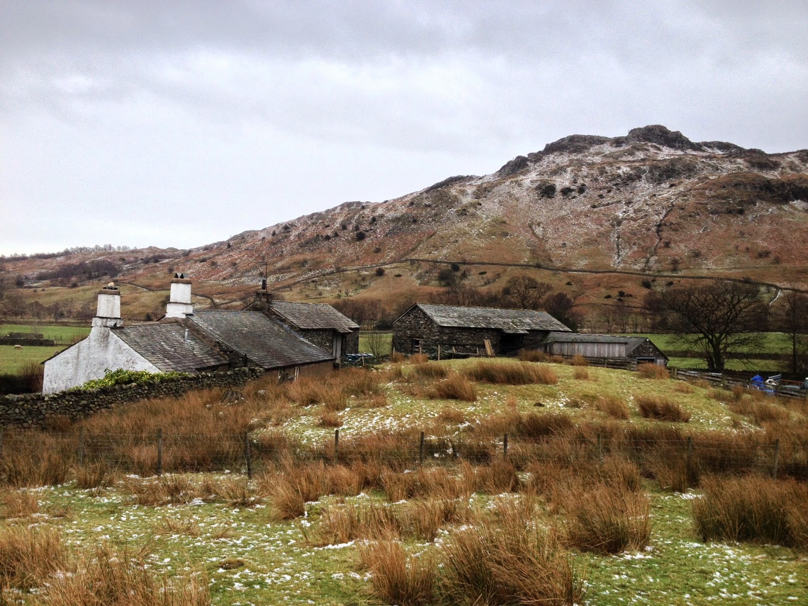 |
| The Ting Moot tucked away behind Fell Foot Farm. The terraced edges are very obvious when you visit. |
Speaking of Castle Howe, this is the last of Little Langdale’s
scheduled monuments, but unfortunately it seems likely that its history isn’t
so compelling. Although it was scheduled
in 2001 as an Iron Age hill fort (based on research from the 1920s), current thinking is that it’s probably not
a fort at all - although, as with all archaeology, we can never be certain. The ditches to the west of the peak, which
were originally interpreted as man-made defensive features, are now thought to
be natural, and a look at the summit suggests that even if ancient people had
created a defensive cordon here, there would be nowhere inside to make
buildings or live due to the steep and rocky ground. Although its human history is in dispute,
Castle Howe is a fascinating piece of geology known as a dyke, formed by a plug
of lava cooling in a vent from a giant volcano. It's consequently made from
harder rock than the surrounding area so while the rest of the landscape was eroded
under the glaciers of successive Ice Ages, these lumps - like Tarnclose Crag and the Langdale
Pikes to the north - stand ruggedly proud.
 |
| Castle Howe (on the right) rises above Fell Foot Farm and the Ting Moot, with Greenburn and Wetherlam beyond. |
There’s a huge amount more history in the valley that there’s not room to
cover here – each of the farms is a fascinating tale in its own right, for
instance – and this just demonstrates the rich story the landscape of the Lakes
has to tell. Little Langdale is
considered one of the Lake District’s gems in terms of scenery, but scratching
beneath the surface can add a whole new level of interest to your hike; the
valley is the perfect place to start an archaeological investigation and walk
in the footsteps of our ancestors.
The rangers work hard with the National Trust regional archaeologist and building teams as well as the tenant farmers to ensure our Scheduled Ancient Monuments and the rest of the amazing history in our landscape is looked after as well as possible. Sometimes this means excluding livestock or cutting vegetation on a monument to ensure it's not eroded, while other times we need to get the experts in to find out more information or carry out structural work. Keep reading our blog to find out more about our varied work in the South Lakes.

5 December 2014
In the frame!
 |
| The Langdale Valley looking over Mickleden. The Pike 'o' Stickle is on the right. See point 2,3 and 4 below with regards to lighting, and composition |
The other day I was stopped by a gentleman at Blea Tarn, after the initial startle of being approached from behind in one of the quietest spots in our portfolio he went on to ask me how to get to hard knot pass and Wasdale. I gave him his directions and inquired what his journey entailed? ‘photography’ he replied.
As you can imagine, the Lake District is a photography location for professionals and amateurs alike. However this gentleman went on to tell me stories of his past, and how he was hired by popular magazines and newspapers to ‘camp out’ in the wild and get some iconic and moody photos for publication -- A dream job for many. In contrast however, his career went in a different way and now some 20 years or so later he is looking to reinvigorate his interest in landscape photography.
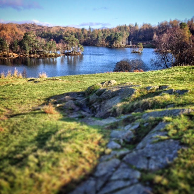 |
| The stunning Tarn Hows, #NTtarnhows I used this strip of bedrock to add foreground interest to my photo. See point 4 below. |
Times have moved on, and now good quality digital cameras are affordable and in many cases come complete with your mobile phone. So what I would like to do is give you some basic observations on taking a memorable picture. I’ve included some of my own photos I have taken whilst on my journey, I don't by any means claim that they are perfect, but they should highlight some of the points I've outlined here. I have also provided links which go into more detail of what I describe here …. And yes, I am very lucky to live and work here.
Get off the track - Look at where you are, don’t take your photograph from the standard point of view on a footpath. If it’s safe, and OK to do so, move closer to your intended target, or maybe get higher, or lower to the ground for some depth.
Lighting - You’ll always get a better lit photograph when the sun is behind you, for more dramatic photography head out early, for what is called the ‘golden hour’, this is the first hour after sunrise, or before sunset. Maybe stay at one of our campsites, to make sure you can get up and out for the sunrise.
Composition - Remember the rule of thirds, in simple terms look at breaking your photograph into 3’s this gives you a much more balanced photo, and is more pleasing to the eye. Click here to learn more about this subject.
Break the rules - Landscape photos don’t need to be taken in a landscape format. Try breaking the rules a little, taking a photo of the fells in portrait gives you a sense of drama and scale. In the square, it gives you a much tighter shot. Most importantly, think about having foreground interest, such as a rock formation, or a dry stone wall maybe?

I use an Iphone to take my photos, and I make use of the filters that are available. These vary from adding a vignette, increasing the saturation or the brightness and the contrast.
27 October 2014
Ghostrider
Beatrix
Potter and Arthur Ransome wrote stories and created characters that
have become part of the culture of this part of the lakes. Tales of
adventures on sunny days, of breezy picnics by the lake, friendships and laughter. But some stories are much much older, these are stories of love and loss of
violent actions with fatal consequence of madness despair and death,
these stories ,centuries old , have been passed from generation to
generation and have been around so long they are now part of the soil,
the water the rocks and the air.
At this time of year these stories seem somehow closer to the surface. Maybe it’s the cold still autumn mornings when the
mist hangs low over the lake, deadening the background noise, allowing
disembodied voices animal and human to reach out through the enveloping grey. Maybe
it was the earth tremor last night; that noise and the shaking woke me
suddenly with a bright blinding light and a searing pain down my spine
and I have had the mother of all headaches ever since.
 |
| Windermere Ferry early morning |
And this is how I start my normal daily commute into work as a countryside Ranger on my trusty iron horse,
a journey I’ve made a thousand times before, but this morning it feels
somehow different, otherworldly, I have a sick feeling in my stomach and
feel so damn cold. A mile along the lakeshore cutting my way through
the mist, the sound of the Windermere car ferry , creaking and groaning
as it pulls itself along on metal chains. I am reminded of the ferry
disaster of 1597. A wedding party 45
strong returning from Far Sawrey cram themselves onto the ferry which
was in those days just a large rowing boat. The outward journey in calm
waters, full of laughter and merriment turned to disaster on their
return as the winds picked up the wedding party high on drink but low on
balance capsized the boat and 38 people drowned. The biggest loss of
life that this lake has seen.
Since
then people have reported seeing faces in these murky waters and
swimmers have felt hands grabbing their ankles trying to drag them under
to join the wedding party. These are probably
just reflections and submerged weeds, but his morning through the mist
the bouys that surround the islands look eerily like floating lifeless
bodies .
 |
| Sawrey Church |
Onward and up ferry hill to the church at Far Sawrey the late flowering devils bit scabious scattered on the grassy road verges. Chattering crows gather on the wall watching me pass by like they’re waiting for something to happen.
Through
the Sawreys and along the side of Esthwaite Water this is always the
coldest part of the ride in, this morning it is icy cold I look out
across the water towards the Devils Gallop. In medieval times when
Hawkshead was the main market town in south Lakeland the packhorse men
would spur the horses on double-quick along this lonely stretch of road
trying to keep one step ahead of old nick. Through the mists I hear the
sound of hooves and a sudden snort of some large hidden beast on the
other side of the hedge gets the adrenaline racing and I put my foot
down on the pedals just that bit faster.
Approaching
Priests Pot, a small circular tarn on the edge of Hawkshead village
past the site of the gibbet. This was an upright wooden post with a
projecting arm for hanging the bodies of executed criminals. A bit like a
giant bird feeder it acted as a blunt warning to the packhorse men
approaching the village, with its 14 public houses, to behave themselves
when they got paid or as a reminder as they were leaving that they may
have got away with it this time but next time they might not be as
lucky.
Riding through the village the speed camera on the corner shouts 13 at me in bright red numbers ( why is it always 13 ) is it trying to tell me something ?
Riding out of the village my nerves on edge not warming up at all I look to my right to Latterbarrow and Claife Heights my
thoughts inevitably stray to the Crier of Claife the ghost that has
haunted the Heights since they were the property of Furness Abbey. There was apparently a house of ill repute on Claife heights where women would provide ‘ refreshment ‘ to the weary packhorse men. A
young monk sent by the Abbey to save these women from a life of sin,
fell in love with one of them, but his advances were spurned and the
rejection eventually sent him mad, he died love lorn and lost on the
heights.
His
restless spirit wandered the heights for years wailing into the night.
One foggy winters evening the ferry men based at Ferry Nab, heard a
desperate call from across the lake “ferryman, ferry man". The ferryman set off into the mist a single lamp on the prow of the boat lighting the way. After some considerable time, the boat eventually drifted back across the lake, with no passenger, no light and the ferryman wide eyed with terror, struck dumb by whatever unspeakable horror that he had witnessed .
Well, that was enough for the locals and they quickly engaged two priests with ‘bell ,book and candle'
to exorcise the ghost’s spirit to a remote quarry on the heights. If
you listen carefully some nights you can still hear strange noises
probably just the screech of an owl, the cry of a fox or the bark of
young stag.
 |
| Claife Under a blood red sky |
Climbing
up Hawkshead Hill ,out of the mist now the ghost of the mad monk seems
to be fading , but the late rising sun offers no heat and has cast a deep bloody hue over everything , the silent ghostly figure of a barn owl sweeps low across the field to my left. It is folklore that these owls carry the souls of the recently departed I look back to see Claife under a blood red sky, and it looks most peculiar.
Up
ahead I can see a black figure crouched over something in the middle of
the road is that a shadow or .... As I get closer the figure stands up
and breaks apart, exploding in ten different
directions at the same time, the sound of a cape?..... no it’s the
sound of wings flapping as a murder of carrion crows disperse into the trees above, not wanting to move too far from what was interesting them lying on the tarmac.
What
was interesting them is a mass of blood and bone and entrails , road
kill of some description feeling bad enough I can’t bear to look too
closely so I cycle on and the pain in my back and the cold are just
getting worse.
I
finally reach the crossroads at High Cross and now have an easy
descent, freewheeling down to our Ranger base in Coniston. The base is
very quiet, unusually quiet for a workday, I walk into the kitchen area and on the table lying open on pages 7 and 8 is the most recent
edition of the Westmorland Gazette and my eye is drawn to a short
article ‘National Trust Ranger killed in early morning traffic accident', gripped by a crushing fear and understanding, the
cold and the pain intensify, the room starts shaking and then suddenly
the pain and the cold disappear along with the colour, the light, the
sound………
When
you are walking the paths and lanes of South Lakeland if you feel a
sudden unexplained rush of wind passing by or the squealing of brakes
when no bike is around to be seen, it might just be me on my way into
work again ........ghostrider.
Paul Farrington (1963-2014)
National Trust Ranger
South Lakes
14 February 2014
A Valentine to Volunteers
This week it is the turn of the South Lakes Upland Ranger team to write this blog and in light of the date it seemed like a great opportunity to remind volunteers that we love them !
Tackling erosion in the fells of the Lake District is a never-ending task and there is much more to do than the teams can possibly cope with. If it wasn't for volunteers we would struggle to keep on top of the maintenance of existing path work let alone undertake new projects.
There is one group of volunteers that is particularly close to our hearts; the 'Fix the Fells Lengthsmen'. A 'lengthsman' is a traditional term for someone who looks after a right of way.
This group of volunteers is involved in upland path work all year round and in all weathers. We frequently work with them and have got to know them fairly well. In fact two of our current team were first involved in upland work as volunteers under this lengthsmen scheme.
The volunteer lengthsmen carry out a range of important tasks. One of the main ones is the "drain run". This involves walking existing routes where path work has been carried out, clearing the drains and clearing any gravel and loose material from the sections of " pitched" stone steps. It is also an opportunity to check the general condition of the paths and report back on areas in need of attention. The lengthsmen do an excellent job of coordinating their own drain runs and most weeks several drain runs take place around the Lake District.
They are also involved in project work which might include repairing or building new drains, pitching sections of path with rock and landscaping to define the main path and remove shortcuts. Much of this is done in work parties with the upland path teams and some mini projects are carried out independently.
It is often a case of 'many hands make light work' and the progress from a work party day can be quite striking.
The lengthsmen are a fantastic group & always willing to get involved & help out even at fairly short notice. Last year, when weather conditions had delayed preparations, they helped us fill bags with rock just in time for the helicopter lifts that moved the rock from the screes to the nearby project site.
Today the South Lakes Upland Ranger team are out on a drain run with some of the lengthsmen and some potential new recruits, who will hopefully enjoy this "taster" day.
More information on volunteering for 'Fix the Fells' can be found using the following link:
http://www.fixthefells.co.uk/who-we-are/our-volunteers
The focus of this blog has so far been our main group of upland footpath volunteers that we have got to know (& love) over the last few years. We are also fortunate to work with lots of other volunteers.
We sometimes have individuals who wish to work with the team, it might be just the odd day or other times a few weeks, perhaps using holidays.
Our volunteer centre at High Wray Basecamp frequently involves us with their volunteer groups. Examples might range from groups of college students doing outdoor courses to rehabilitation groups.
Other volunteers include groups that enjoy the fells in their leisure time. Aware that they are contributing to the erosion problems they also want to do their bit to help.
We usually run two upland footpath working holidays each year. This involves up to 12 individuals joining us for a week's "holiday" working on our upland path projects.
It has only been possible to include a selection of volunteers that we have the pleasure to work with. However our message is the same to all volunteers:
"Thank you !"
If you would like to know more about the daily work of the South Lakes Upland Ranger team they can be found on Twitter @NTLakesFells.
Posted by: Nick, Upland Ranger
Tackling erosion in the fells of the Lake District is a never-ending task and there is much more to do than the teams can possibly cope with. If it wasn't for volunteers we would struggle to keep on top of the maintenance of existing path work let alone undertake new projects.
There is one group of volunteers that is particularly close to our hearts; the 'Fix the Fells Lengthsmen'. A 'lengthsman' is a traditional term for someone who looks after a right of way.
This group of volunteers is involved in upland path work all year round and in all weathers. We frequently work with them and have got to know them fairly well. In fact two of our current team were first involved in upland work as volunteers under this lengthsmen scheme.
 |
| A work party with Fix the Fells Lengthsmen last summer on a path project up Fairfield. A lovely day! |
 |
| Lunchtime with lengthsmen: sheltering last week with a few volunteers on a work party near Blea Tarn. Not such a nice day ! |
They are also involved in project work which might include repairing or building new drains, pitching sections of path with rock and landscaping to define the main path and remove shortcuts. Much of this is done in work parties with the upland path teams and some mini projects are carried out independently.
 |
| Lengthsmen building a drain on a route up Coniston Old Man. |
 |
| A section of erosion developing on a path by Raise Beck. |
 |
| Fix the Fells lengthsmen hard at work on the eroding section. |
 |
| The results of the work party - a much better looking section of path. |
Today the South Lakes Upland Ranger team are out on a drain run with some of the lengthsmen and some potential new recruits, who will hopefully enjoy this "taster" day.
More information on volunteering for 'Fix the Fells' can be found using the following link:
http://www.fixthefells.co.uk/who-we-are/our-volunteers
The focus of this blog has so far been our main group of upland footpath volunteers that we have got to know (& love) over the last few years. We are also fortunate to work with lots of other volunteers.
We sometimes have individuals who wish to work with the team, it might be just the odd day or other times a few weeks, perhaps using holidays.
 |
| Two volunteers from the Netherlands helping us with our Fairfield path project last summer. |
 |
| Volunteers from a rehabilitation group working on our Blea Moss path project |
 |
| 'West Runton' helping on the Blea Moss path project. (A group that have been coming to High Wray Basecamp for many years) |
 |
| Kendal Fellwalkers helping us on a drain run up Browney Gill in January (Weather looks nice here....but not for long....) |
 |
| Our working holiday group on the Fairfield path project last September. (Probably some of the worst weather we had on the fells last year.) |
It has only been possible to include a selection of volunteers that we have the pleasure to work with. However our message is the same to all volunteers:
"Thank you !"
If you would like to know more about the daily work of the South Lakes Upland Ranger team they can be found on Twitter @NTLakesFells.
Posted by: Nick, Upland Ranger
Subscribe to:
Posts (Atom)